Tropisk skog
Tropisk skog
Tropical forest monitoring
Recent international initiatives, like GEO-FCT and UN-REDD, aim at reducing deforestation and forest degradation in tropical countries. In order to quantify the yearly deforestation accurately, new remote sensing techniques need to be developed. Also, change-detection systems need to be implemented as operational monitoring systems, in order to stop illegal logging activities.
The scope of these systems is so large that no single research institute can develop them alone. Rather, international collaboration is needed. NR will focus on automatic image coregistration, automatic forest mapping, and automatic forest change detection. Central to both forest mapping and forest change detection is the use of time series to overcome missing data and to capture natural variation. Missing data is mainly due to varying cloud cover in the tropics. Natural variation may lead to misclassification if a single image is used for land cover classification. These errors will add up if two classified images are used for change detection.
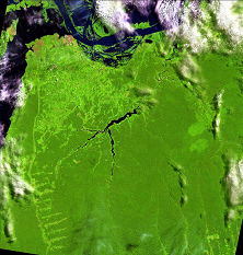
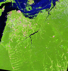
Landsat 5 TM scene 227-062. Left: 8 July 1996, right: 28 July 2009. Bands 3, 4, and 5 are shown as blue, green, and red, respectively. Images downloaded from INPE, Brazil.
Contact information

Project period
Financing
Norwegian Space Centre
 Hvordan komme til NR
 Del på sosiale media
 Personvernerklæring