Description of the Study Areas in Italy
Description of the Study Areas in Italy
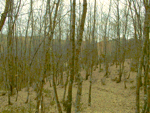
Forest from the Radicondoli test area in the Tuscany region, Italy (photograph: Martti Hallikainen)
Tuscany is a region of central Italy that can be divided in three different ecological zones: the Mediterranean zone, the basal zone and the mountain zone.
Their main characters can be described as below reported:
The Mediterranean zone
- It is characterised by long dry periods during summer and warm winter. It is comparable to Lauretum .
- aver. annual temp. 12° / 18°C
- aver. temp. for the coldest month 3° / 7°C
- aver. annual rainfall 600 / 800 mm
- dry period 45 / 60 days
- altitude 0 / 300 m a.s.l.
- The most important species we find in this zone are oaks (mainly Quercus ilex L.) and pines (Pinus pinaster Ait. and Pinus pinea L.). The most typical formation is maquis: dense stands with small trees and many bushes. The main problem for forest managers is forest-fire.
The basal zone
- It includes the hills and the low valleys. Chestnut (Castanea sativa Mill.) ,Turkey oak (Quercus cerris L.) and Quercus pubescens L. are the typical species in these areas; according to local conditions we can also find Populus alba L. and Populus nigra L.-groves or reafforestations with softwoods and hardwoods. According to Pavari, the basal zone is included into the Castanetum
- aver. annual temp. 10° / 15°C
- aver. temp. for the coldest month -1° / 3°C
- aver. annual rainfall 700 / 800 mm
- dry period 30 days
- altitude 300-400 / 800 m s.l.m.
The mountain zone
- It is characterised by a temperate climate with cold winter. Beech (Fagus sylvatica L.),fir (Abies albaMill.) and pine (Pinus nigra Arnold) are the most widespread species. In addition to these, there are forests with ashes (Fraxinus excelsior L. ) and maples (Acer pseudoplatanus L.) which are of less extension if compared to the ones already mentioned. According to Pavari (1916), this zone can be compared to Fagetum
- aver. annual temp. 7° / 12°C
- aver. temp. for the coldest month -2° / -3°C
- aver. annual rainfall 1100/1200 mm
- dry period 0 day
- altitude 800 / 1900 m a.s.l..
Selected areas
The areas that have been selected are representative for the main ecosystems in the region. The first area is situated in the Mediterranean zone (S Rossore), the second is in the basal zone (Radicondoli) and the third in the mountain zone (Vallombrosa). This last zone is not really belonging to the Mediterranean environment, since it shows more temperate features, but its consideration is recommended in order to cover all main regional ecological situations.
The picture here below shows how the three different environmental zones are represented and the locations of the selected areas.
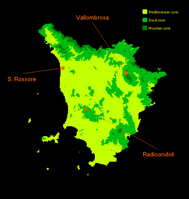
Distribution of the 3 main ecological zones in Tuscany (the Mediterranean zone is green, the
basal zone is blue and the mountain zone is yellow) and location of the 3 proposed sample areas.
San Rossore
The sample area is part of the Natural Park of Migliarino "San Rossore" Massaciuccoli and is located within the pine wood of Pinus pinaster Ait. that is present along the coastline.
from Viareggio to Pisa. In addition there is Pinus pinea L. but our sample area doesn't include it. Pinus pinaster Ait. is generally distributed closer to the sea than Pinus pinea L. because of its higher resistance to salinity and air pollution. Most of the pine woods were planted since 1765, when all the area was used by the Tuscany Grand Duke.
All the area, being close to the sea-coast line, is flat and the sandy soils are vulnerable to the infiltration of saline water.
Problems connected with the management of the pine-forests are: control of fires, control of pests and diseases and control of natural tree renovation. This tree renovation is commonly dependent on fires or other disturbances because pines are light dependent and their seeds germinate better after being exposed to high temperature.
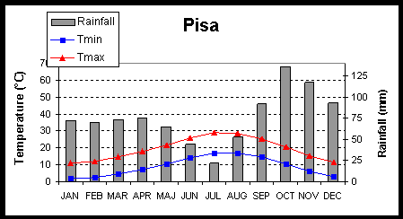
Diagram of mean temperatures and rainfall derived from a station
close to the first sample area (San Rossore, Mediterranean zone).
Radicondoli
Radicondoli is a test site of about 15x15 km located near the centre of Tuscany. The terrain is mainly hilly, with elevation ranging from 400 m a.s.l. in the valleys to about 900 m a.s.l. in the upper zones. The climate can be defined as Mediterranean subhumid, characterised by a long arid season in summer (Rapetti and Vittorini, 1995).
The land is used prevalently for agriculture in the valleys (mainly spring crops and pastures) and for forests in the upper zones. The most common spring crops are wheat and alfalfa, while forests, which cover about 70% of the area, consist predominantly of mixed oak woods (Quercus pubescens L. and Quercus cerris L.) and some stands reforested with pines (Pinus nigra Arnold).
Oak woods (Quercus cerris L. and Quercus pubescens L., mainly) are the most widespread typology within the basal zone. Their importance is related to the relevant role they had for country economy. Most of the woods that once were coppiced are now abandoned; in some cases they are in bad conditions because during the last decades they were too intensively exploited. High forest is the best ecological choice for these woods but to reach this condition is not economically convenient.
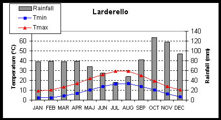
Diagram of mean temperatures and rainfall derived from a station
close to the second sample area (Radicondoli, basal zone).
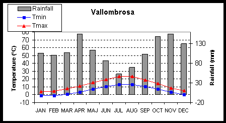
Vallombrosa
Vallombrosa is situated close to the Appennino mountain, Central Italy. This area is all covered by forests from 530 to 1350 m a.s.l.
The soil is generally acid because of the characters of rocks and of climate (the average annual rainfall is around 1350 mm so most of the nutrients are leached); in addition, where firs (Abies alba M.) are present, also the litter is acid. The most important species are: Abies alba M., Fagus sylvatica L. and Castanea sativa Mill.. Obviously they are widespread according to their ecological characters. Chestnuts are in fact in the lower part of the area while beeches and firs are in the upper part of it because of their higher resistance to low temperature and shorter growing period. The management of the all area is now changing in relation to the forests uses which have changed in the last few years. The original forest practices aimed at timber production and have been substituted by more modern management politics implying minimum human interferences. This means that most of the old monospecific plantations start to be diversified and more evergreens are present.
Fir woods (Abies alba Mill.) are typical for the mountain region where they have been cultivated since the XV century. They were planted to obtain timber for buildings. Their management, since they are out of their natural environment, is not easy. Firs in fact prefer colder climate and in Tuscany they are often attacked by pests and diseases.


 How to get to NR
 Share on social media
 Privacy policy