SatTrafikk
SatTrafikk
Vehicle detection using satellite images
, acquired using the QuickBird satellite. Two dark vehicles can be seen in this image. The road has been outlined in red.") The SatTrafikk project is a cooperation between NR and the Norwegian Public Roads Administration (Statens Vegvesen, Vegdirektoratet) where the aim is to develop automatic methods for retrieval of road traffic statistics by satellite remote sensing. Using very high resolution satellite images we are trying to teach the computer how to count the number of vehicles on given roads.
The SatTrafikk project is a cooperation between NR and the Norwegian Public Roads Administration (Statens Vegvesen, Vegdirektoratet) where the aim is to develop automatic methods for retrieval of road traffic statistics by satellite remote sensing. Using very high resolution satellite images we are trying to teach the computer how to count the number of vehicles on given roads.
The road authorities use traffic statistics information when they are planning construction and maintenance of the road network. As seen from 450 kilometres above the surface of the earth, the vehicles are pretty small. Tree shadows and road markings often disturb the view, and make this task a challenging one - especially since Norway is full of curvy, narrow roads!
In the current situation, the Norwegian Public Roads Administration uses ground-based sensors to collect traffic statistics. The basis curve method (developed in the past by NR) is used to estimate the annual average daily traffic (AADT), including precision estimate, for count sites where counts are available for only a limited part of the year. The method is based on a statistical regression model, the complexity of which is adapted to the amount of data available. Traffic statistics have historically been collected for a large number of roads in Norway, and given us an overview of statistical trends (see below figure). Given these trends, and the date and time of image acquisition, it is possible to estimate the yearly average number of vehicles per day for the imaged road segment.
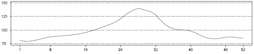
 and hourly basis over a week (bottom) scale.")
Latest project news
|
2011 was the last year of funding from the Norwegian Space Centre for the SatTrafikk project, which was started in 2007 as a follow-on to the European Space Agency project Road Traffic Snapshot (2006-2007), which demonstrated the feasibility of this kind of vehicle detection. In order to apply the SatTrafikk vehicle detection software in operational scenarios, several key components must work together. Up until 2010, modules for the detection of roads, vehicles, and clouds and cloud shadows, were separately developed. Updated date: Torsdag, november 15, 2012 - 12:56 |
Contact information

Project period
Financing
The Norwegian Space Centre (Norsk Romsenter) and The Norwegian Public Roads Administration (Statens Vegvesen Vegdirektoratet, SVV)
 Hvordan komme til NR
 Del på sosiale media
 Personvernerklæring