COHIBA 7.0 - Surface Modelling and Depth Conversion
COHIBA 7.0 - Surface Modelling and Depth Conversion
Request free trial license
COHIBA Version 7.0 was released March 26th 2021. Important improvements are:
- Surfaces can be conditioned on distance data from resistivity measurements (DDR data, RNS data). This is invaluable for geosteering as they reduce the uncertainty of top reservoir significantly. distance data also allow wells to be correctly positioned relative contacts (OWC, GOC).
- Surfaces can be conditioned on surface dip.
For a complete list of all modifications please consult the release notes in the user manual.
Why use COHIBA:
- Conditions to vertical and horizontal wells using various well data: well picks, zone logs, distance data (DDR/RNS), and surface dips
- Handles many surfaces and explicitly takes into account their internal dependencies.
- Handles well path TVD uncertainty in multilateral horizontal wells.
- Analyzes input data, filter away erroneous data, and reports problems.
- Thorough analysis of model and data. Extensive reporting.
- Handles large amount of data.
- Stochastic depth-conversion.
- Cross validation of wells.
COHIBA is a fast and accurate tool for making deterministic and stochastic surfaces. COHIBA can use information from:
- Surface observations in wells (well points)
- Horizontal well paths with zone logs
- Seismic travel time maps
- Interval velocity maps and models
- Isochore maps and models
- Spill point depth
COHIBA uses the available data in a consistent manner to minimize the uncertainty. The accuracy is further improved by linking together all surfaces in a multi-layered model.
COHIBA provides two ways of evaluating uncertainty:
- A local depth uncertainty at every surface location can be calculated
- Simulated (Monte Carlo) surface realizations can be generated. A set of these spans the uncertainty range
For details and examples please have a look at the COHIBA user manual:
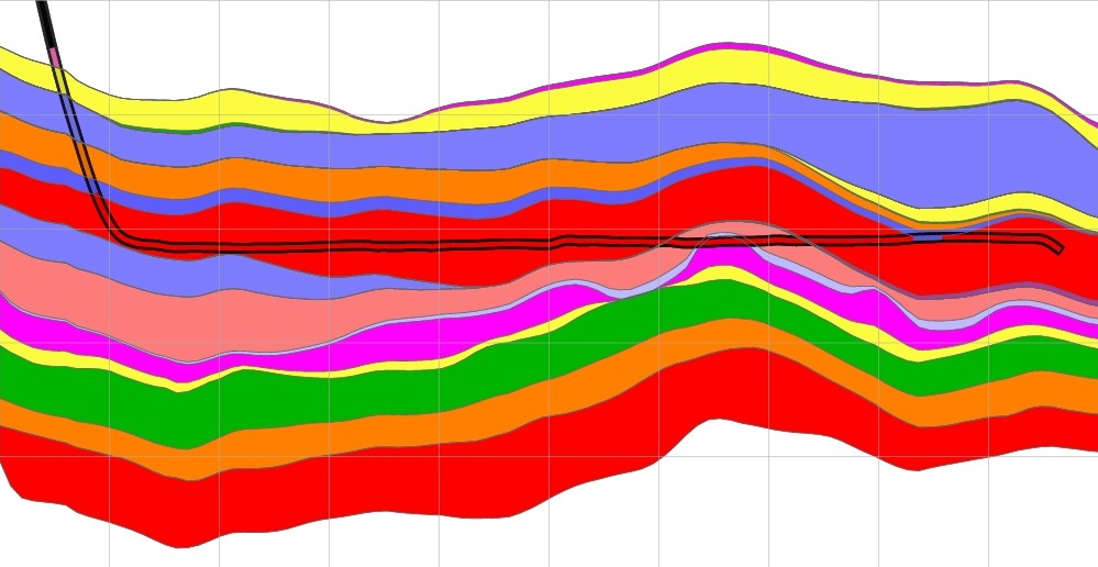
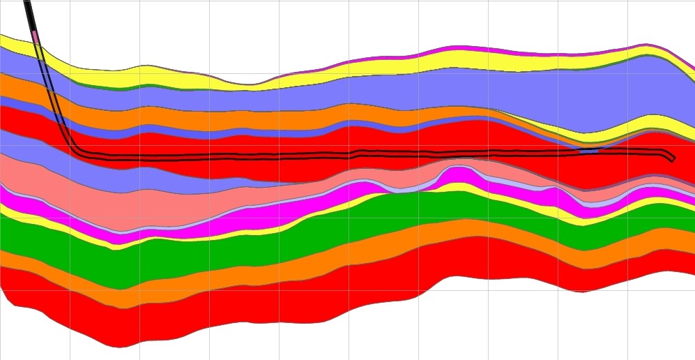
Conditioning to well points versus conditioning to well paths
Below are two cross sections showing the improvements obtained by conditioning the surfaces to well paths in addition to the well points. The left figure is obtained using only well points while the right picture is obtained using both well points and well paths. Note how all surfaces are modified to obtain consistent and realistic zonation.
Below is a second example. Again we see how COHIBA modifies all surfaces to make a consistent and realistic zonation.
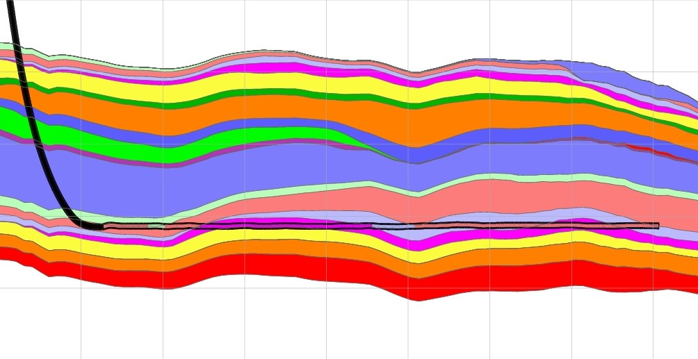
Uncertainty reduction
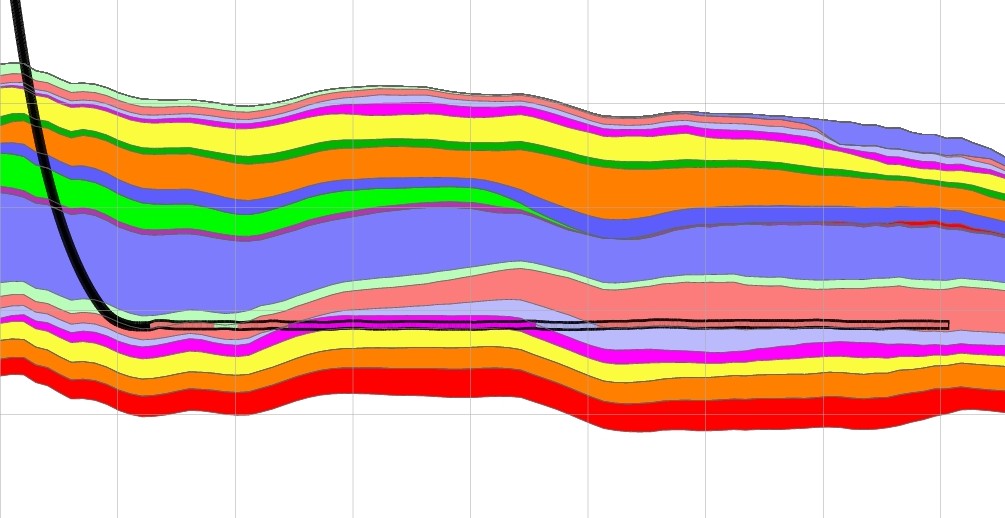
The following picture shows the result of conditioning to well paths. We clearly see how the surfaces are accurately determined along the well paths.
.jpg)
The left-hand pictures show the results from using well points whereas the right-hand pictures show the results from using both well points and the well paths. The uncertainty is significantly reduced along the well paths because the well trajectories are confined to very thin zones similar to the situations in the cross sections above.
Geosteering
The animation below simulates the use of distance data acquired from deep directional resistivity (DDR) logs during a drilling process, and shows a vertical cross section along a planned well trajectory. The reservoir consists of a top and a base surface with the reservoir zone in red. The planned trajectory is shown as a continuous line entering the top of the anticline and passing through the reservoir. The actually drilled trajectory starts to deviate from the planned well as the true distances to the top and base reservoir are updated. The dashed lines represent the surface uncertainty envelopes and shrinks as more data becomes available.

Publications
- Bárbara, Carla Patricia; Cabello, Patrícia; Bouche, Alexandre; Aarnes, Ingrid; Gordillo, Carlos; Ferrer, Oriol; Roma, Maria; Arbués, Pau. (2019), Quantifying the impact of the structural uncertainty on the gross rock volume in the Lubina and Montanazo oil fields (Western Mediterranean). Solid Earth (SE) (ISSN 1869-9510). 10(5) pp 1597-1619. doi: 10.5194/se-10-1597-2019.
- M. Vigsnes, O. Kolbjørnsen, V.L. Hauge, P. Dahle and P. Abrahamsen (2017), Fast and Accurate Approximation to Kriging Using Common Data Neighborhoods, Math Geosci 49: 619. https://doi.org/10.1007/s11004-016-9665-7
- (2015) Surface prediction using rejection sampling to handle non-linear constraints Bulletin of Canadian Petroleum Geology, December 2015, v. 63, p. 304-317,
-
L.P. Jensen, E. Stürup-Toft, S. Pearse, and A. Cherrett (2015). An integrated approach to geostatistical depth conversion and gross rock volume estimation, Interpretation 3(1), SC9-SC17, https://doi.org/10.1190/INT-2014-0030.1
-
P. Abrahamsen (2005), "Combining Methods for Subsurface Prediction", in O. Leuangthong and C.V. Deutsch (eds.) "Geostatistics Banff 2004", Vol. 2, Springer, Dordrecht, pp. 601-610
-
P. Abrahamsen and F.E. Benth (2001), "Kriging with Inequality Constraints", Math. Geol. Vol. 33 No. 6, pp. 719-744.
-
P. Abrahamsen, R. Hauge, K. Heggland, P. Mostad (2000), "Estimation of Gross Rock Volume of Filled Geological Structures With Uncertainty Measures", SPE Reservoir Evaluation & Engineering, Vol 3, No. 4, pp. 304 - 309, doi: 10.2118/65419-PA
-
P. Abrahamsen (1993), "Bayesian Kriging for Seismic Depth Conversion of a Multi-layer Reservoir" in A. Soares (ed.) "Geostatistics Troia '92". Kluwer Academic Publ., Dordrecht, pp. 385-398
-
H. Omre (1987), "Bayesian Kriging - Merging Observations and Qualified Guesses in Kriging" Math. Geol. Vol. 19, No. 1, pp. 25-39. doi: 10.1007/BF01275432
Conference contributions:
-
P. Abrahamsen, V. Kvernelv and D. Barker (2018), Simulation Of Gaussian Random Fields Using The Fast Fourier Transform (FFT), ECMOR XVI - 16th European Conference on the Mathematics of Oil Recovery, DOI: 10.3997/2214-4609.201802134
-
P. Dahle, P. Abrahamsen, A. Almendral-Vazquez (2015), Simultaneous prediction of geological surfaces and well paths. Conference, Petroleum Geostatistics, Biarritz, France, September 7–11, 2015. Full text.
- Petter Abrahamsen, Pål Dahle, Vera Louise Hauge, Ariel Almendral-Vazquez and Maria Vigsnes, (2014) Surface prediction using rejection sampling to handle nonlinear relationships, presented at the 2014 Gussow Geosciences Conference, September 22.-24., 2014, Banff, Canada, pdf,
- A. Mannini and S. Pearse (2014), How Big an Elephant Can Be, presented at 76th EAGE Conference and Exhibition, Amsterdam June 2014, doi: 10.2118/159746-MS
- K. B. Neumann, B. K. Hegstad, E. Bratli, I. K. Osmundsen (2012), Uncertainty study on in-place volumes in Statoil, presented at Ninth International Geostatistics Congress, Oslo, Norway, June 11 – 15, 2012.
- Abrahamsen, Petter; Dahle, Pål; Skorstad, Arne (2012). A Fast and Consistent Geostatistical Approach for Constraining 3D Structural Models to Horizontal Wells. presented at EAGE workshop Integrated Reservoir Modelling - Are we doing it right?, 25.-28. November 2012, Dubai, Full-text
- V.R. Stenerud, H. Kallekleiv, P. Abrahamsen, P. Dahle, A. Skorstad, M.H. Aalmen Viken, Added Value by Fast and Robust Conditioning of Structural Surfaces to Horizontal Wells for Real-World Reservoir Models, SPE Annual Technical Conference and Exhibition, 8-10 October 2012, San Antonio, Texas, USA, doi: 10.2118/159746-MS
- Petter Abrahamsen, Pål Dahle, Frode Georgsen and Arne Skorstad (2010), "A Consistent Geostatistical Approach for Constraining Multiple Surfaces to Horizontal Wells", poster presented at GEO 2010, 9th Middle East Geoscience Conference and Exhibition, 7 - 10 March 2010, Manama, Bahrain
- P. Abrahamsen and H. Omre (1994), "Random Functions and Geological Surfaces", in proceedings "ECMOR IV, 4th European Conference on the Mathematics of Oil Recovery, Røros, Norway, 7-10 June 1994.
Institute reports:
- P. Abrahamsen (1999), "FFT algorithm for simulating Gaussian random fields", Report, NR-note SAND/10/99, 28 pages
- P. Abrahamsen (1996), "Geostatistics for Seismic Depth Conversion", Report, NR-note SAND/06/1996, 9 pages.


Project period
Links
Previous user manuals:
Partners
- Equinor
- Roxar/Emerson
- Wintershall DEA
- Total S.E.
- AkerBP
- Lundin
 How to get to NR
 Share on social media
 Privacy policy